
Open User Map
Open User Map lets you build a map your visitors can add to, approve, and customize without coding or Google Maps API keys.
Visit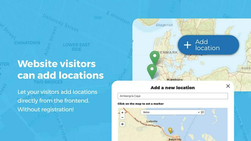
About Open User Map
Open User Map is a powerful, interactive maps plugin designed specifically for WordPress, enabling you to create a dynamic map that your website visitors can actively contribute to. This tool transforms a static map into a living, evolving resource where users can add, edit, and interact with location data directly from the frontend of your site. The core value proposition is simplicity and accessibility: you can build a fully functional, community-driven map without writing any code, without needing a Google Maps API key, and without a complex setup process. It is designed for a wide audience, including local business owners, community organizers, tourism boards, event planners, real estate agents, and anyone who wants to crowdsource location-based information. The plugin is built on a philosophy of continuous improvement, allowing you to start with a basic map and iteratively enhance it with features like approval workflows, custom fields, categories, and advanced filtering. With over 15,000 active installs and a 100% five-star rating on WordPress.org, Open User Map has proven to be a reliable and user-friendly solution. It empowers you to gather user-generated content, maintain quality control through moderation, and present a beautifully organized map that serves as a central hub for your community or business. The iterative nature of the tool means you can launch a simple map quickly and then layer on complexity, such as adding lines and areas, custom images, or rating systems, as your needs evolve. This approach ensures that you are always building upon a solid foundation, making your map more valuable and engaging over time.
Features of Open User Map
Frontend Location Submission and Editing
Enable your website visitors to add and edit locations directly on your map with a simple, intuitive interface. When a user clicks the 'Add location' button, they can place a marker on the map, fill in details like name, description, and custom fields, and submit the entry. Crucially, all submissions are held for your approval before they become publicly visible, ensuring quality and accuracy. The editing capability allows users to return and update their existing locations, ensuring the map always reflects the most current information without requiring your manual intervention. This cyclical process of user input and admin review creates a continuously improving, accurate map.
Effortless Categorization and Filtering
Organize your map markers into distinct categories, each with its own unique icon and color, to create a clear and visually appealing layout. This feature allows visitors to filter the map to see only the types of locations they are interested in, whether that is restaurants, parks, events, or service areas. For maximum flexibility, a single location can belong to multiple categories, ensuring it appears in all relevant filter results. This system turns a potentially cluttered map into a highly navigable and user-friendly tool, allowing your audience to explore data iteratively by toggling different categories on and off.
Lines and Areas for Complex Mapping
Go beyond simple point markers by adding routes, paths, zones, and regions directly to your map. The Lines and Areas feature allows you to highlight trails, service areas, event grounds, neighborhoods, construction zones, or any custom shape that provides valuable context. Distances and area sizes are calculated automatically, providing helpful measurements for hiking trails, delivery zones, or property boundaries. This feature is essential for creating a comprehensive map that communicates not just where things are, but also how they are connected or delineated, adding a new layer of iterative detail to your visual data.
Advanced Filter Interface
Create a dedicated filter sidebar that appears next to your map, providing a powerful and intuitive way for visitors to explore your data. This interface allows users to filter locations by any custom field you have configured, such as price range, date, or type of service. You can also add custom HTML content sections to the sidebar for additional information, branding, or instructions. This advanced filtering capability transforms the user experience from simple browsing to targeted discovery, enabling a cyclical process of narrowing down results until the perfect location is found.
Use Cases of Open User Map
Community-Driven Local Business Directory
Create a vibrant, user-maintained directory of local businesses in your town or city. Residents can add their favorite coffee shops, restaurants, boutiques, and service providers, complete with descriptions, photos, and categories. The approval workflow ensures only legitimate businesses are listed, while the upvote and star rating features help the best locations rise to the top. This creates a continuously updated, community-vetted resource that becomes more valuable over time as more people contribute and refine the data.
Interactive Event and Festival Map
Build a detailed map for a large event or festival, allowing attendees to see the layout of stages, food vendors, restrooms, first aid stations, and parking areas. You can use the Lines and Areas feature to outline event zones and walking paths. Attendees can even add their own meet-up spots or report issues. The custom image map feature is perfect for overlaying a map onto a detailed venue floor plan. This creates an iterative, real-time guide that improves the attendee experience from year to year.
Crowdsourced Trail and Recreation Map
Develop a map for a national park, hiking club, or outdoor recreation area where users can contribute trails, points of interest, and campsites. The Lines feature is ideal for drawing hiking and biking routes with automatic distance calculations. Users can submit photos, difficulty ratings, and condition reports. The approval workflow allows moderators to verify trail accuracy and safety. This creates a living, breathing guide that is constantly updated by the community, ensuring hikers always have the most current information.
Real Estate and Property Showcase
Use Open User Map to create an interactive property listing map for a real estate agency or a city development project. Agents can add properties with custom fields for price, number of bedrooms, and square footage. The filtering interface allows potential buyers to quickly narrow down properties within their budget and requirements. You can also use the Lines and Areas feature to highlight school districts, neighborhood boundaries, or upcoming development zones. This provides a dynamic, iterative tool for property discovery that is far more engaging than a static list.
Frequently Asked Questions
Do I need a Google Maps API key to use Open User Map?
No, you do not need a Google Maps API key. Open User Map uses OpenStreetMap as its default map provider, which is completely free and does not require any API keys or credit card information. This eliminates a major barrier to entry and makes the plugin incredibly easy to set up and use, allowing you to focus on building your map rather than managing API credentials.
How does the approval workflow for user submissions work?
When a website visitor submits a new location or edits an existing one, the entry is held in a pending state and is not visible on the public map. You, as the site administrator, will receive a notification and can review the submission from your WordPress dashboard. You can then approve, edit, or reject the submission. This ensures that all content on your map is accurate, appropriate, and meets your standards before it goes live.
Can I customize the information that users submit for each location?
Yes, you can fully customize the submission form using the Custom Fields feature. You can add text boxes, links, checkboxes, dropdown menus, and even opening hours fields with a live "Open Now" indicator. This allows you to gather exactly the information you need, whether it is a business's website URL, a restaurant's cuisine type, or an event's date. This flexibility ensures your map data is as comprehensive and useful as possible.
Is there a way to see which locations are the most popular or highest rated?
Yes, Open User Map includes upvote/like and star rating features that you can enable. Visitors can upvote or like locations to help highlight the best places or flag inappropriate content. You can also enable a full 1-5 star rating system, allowing your community to rate locations. These features automatically surface the most popular and highest-quality locations, creating a self-regulating, community-driven curation system that improves the overall value of your map.
Similar to Open User Map

Unifyca centralizes WordPress agency management with automated audits, secure documentation, and proactive maintenance for continuous improvement.

Monitoristic provides real-time website health tracking with instant alerts and customizable status pages for seamless uptime management.

Shadcn Examples offers ready-to-use React and Tailwind UI kits, featuring diverse components and layouts for building web apps efficiently.

WhatTime.dev is your go-to tool for effortlessly comparing time zones and scheduling meetings across the globe, enhancing team collaboration.

Webleadr effortlessly connects you with web design leads and businesses lacking websites, enabling quick outreach from anywhere.

Idearium crafts memorable websites that grow your business through continuous refinement.

Effortlessly host and share files in seconds with FilexHost's simple drag-and-drop interface and automatic URL.

CrawlKit extracts structured data from any website or platform with a single API call, simplifying your data collection.